Feeds:
Posts
Comments

GIS Workshops are still open for the WLIA conference in Green Bay, WI – Wednesday February 18th, 2015


Click here WLIA Annual Conference Workshops or on the logo below to see what workshops are offered and to register.

WLIA logo


There are a variety GIS courses being offered:

  • Introduction to Python Scripting for ArcGIS 10.x
  • Open Street Maps iD Editor
  • Visualizing With CartoDB
  • Transforming Workplace Conflict Into Understanding
  • An Overview of Datums, Adjustments and Wisconsin County Coordinate System
  • Introduction to QGIS
  • Airborne Lidar
  • Intro to ArcGIS Pro


I am going to attend “An Overview of Datums, Adjustments and Wisconsin County Coordinate System”.  This will be very useful for both GPS and GIS users.

  • My co-worker Gale and I will be presenting on Thursday February 19th at 2pm – Track 1: “HIGH ACCURACY GPS FOR GIS – Using WISCORS for Real-Time or Post Processed Corrections”.


Click on the image below to view the WLIA 2015 Conference Program.

See Page 12 thru 13 for the Educational session on Thursday February 19th and Friday the 20th.

WLIA 2015 Conference Program

 Trimble R1 GNSS Receiver

Trimble R1 Sub Meter GNSS Receiver

Trimble R1 Sub Meter GNSS Receiver

Trimble R1:

  • Rugged, compact and lightweight receiver.
  • Sub-Meter Real-Time horizontal accuracy via the following correction types: SBAS, VRS, RTX.
  • Capable of supporting multiple satellite constellations, including GPS, GLONASS, Galileo and BeiDou.
  • Bluetooth to a variety of hardware: iOS (7/8), Android (4.1 or greater), Windows (7 or greater), Windows Mobile (6.5 or greater).
  • Works with Trimble Mapping & GIS software— including Trimble TerraFlex™, Trimble TerraSync™, and Trimble Positions™ software—or third-party applications.

Trimble R1 website Trimble R1 Data Sheet Trimble R1 Technical Support

BYOD:  Bring Your Own Device and connect to the Trimble R1 GNSS Receiver

Learn more about the different devices and software’s that can connect to the Trimble R1 via the March 4th webinar.

Sign up here for the March 4th 2015 Webinar:

8AM (MST) or 4PM (MST)

  • In this webinar, attendees will learn:

    • How consumer-grade smart devices obtain location data and the challenges using built-in GPS functionality
    • The limitations of consumer-grade smart devices when used in professional GIS applications and workflows
    • How to increase and improve location data collection accuracy using the new Trimble R1 GNSS receiver with your smart device
Trimble R1 Webinar March 4th 2015

Trimble R1 Webinar March 4th 2015

TerraSync 5.65, GPS Pathfinder Office 5.65 and Trimble MGIS Compatibility List January 2015

TerraSync and Pathfinder Office:

TerraSync 5.65

  • TerraSync now supports Trimble RTX correction services on the Geo 7X.
  • The option to Navigate to Start Point has been added to the Navigation Options.
  • You can now paste a value copied from the Rangefinder utility into any text or numeric field.
  • TerraSync 5.65 Release Notes

GPS Pathfinder Office 5.65

Trimble MGIS Compatibility List January 2015

  • Look up Trimble Mapping/GIS software and hardware compatibility.
  • The Guide that will save time, money and IT headaches.

What is Trimble RTX?

  • Trimble RTX is a Real-Time cellular data correction service that works with the Geo 7X and TerraSync 5.65.
  • It is a subscription based service that can be used in areas where traditional Real-Time Corrections services such as DOT VRS/RTN’s may not available.
  • Accuracy: This will depend on what subscription is purchased and which Options are enabled on the Geo 7X and TerraSync software.  Speak to your sales representative for more details.

Center Point Subscriptions:

  1. CenterPoint® RTX (via cellular)2
    Horizontal. . . . . . . . . 4 cm HRMS
    Vertical. . . . . . . . . . . 10 cm VRMS
  2. RangePoint™ RTX (via cellular)1. . . . 30 cm HRMS
  3. ViewPoint RTX (via cellular)1. . . . . . . 50 cm HRMS

1 Accuracy and reliability may be subject to anomalies due to multipath, obstructions, satellite geometry, and
atmospheric conditions. Always follow recommended GNSS data collection practices. Specified Centimeter accuracy
can normally be achieved for baselines of 30 km or less. Specified H-Star accuracy can normally be achieved
for baseline lengths of 100 km or less. Centimeter and H-Star accuracy is typically achieved within 2 minutes.
CenterPoint RTX accuracy is typically achieved within 30 minutes. RangePoint RTX and ViewPoint RTX accuracy is
typically achieved within 5 minutes.

2 Stated accuracy is with Trimble Zephyr™ Model 2 GNSS antenna. Requires the Geo 7 series Centimeter Option.


Seiler Mapping GPS Tune-UP

Available January 5 through April 30, 2015

Spring Data collection season is just around the corner.  Is your GPS unit up to the task?

  • This winter you can ensure that your Trimble Mapping device is 100% up-to-date and ready to go for another data collection season.

Geo7x Snow Hydrant2

For our Seiler 2015 GPS Mapping Tune-Up: Click here for more details

Trimble Preferred Service Provider

TerraFlex 3.x Advanced released – January 7th 2015


Whats new:

  • TerraFlex Advanced edition:

    Data update workflows allow users to import pre-existing or pre-collected asset or GIS data into TerraFlex projects, make real-time updates to it in the field, and share that information across the project organization. Users can:

    • Import existing data from shapefiles
    • Create field collection templates from existing attribute tables/layers
    • Create tasks:
      • Show task progress in field
      • Show task progress in office
    • Push existing data to field users
    • Update geometries by field users
    • Update attributes by field users
    • Update attributes by office users

Download the latest TerraFlex from here:  “TerraFlex-Data-Collection-Downloads”

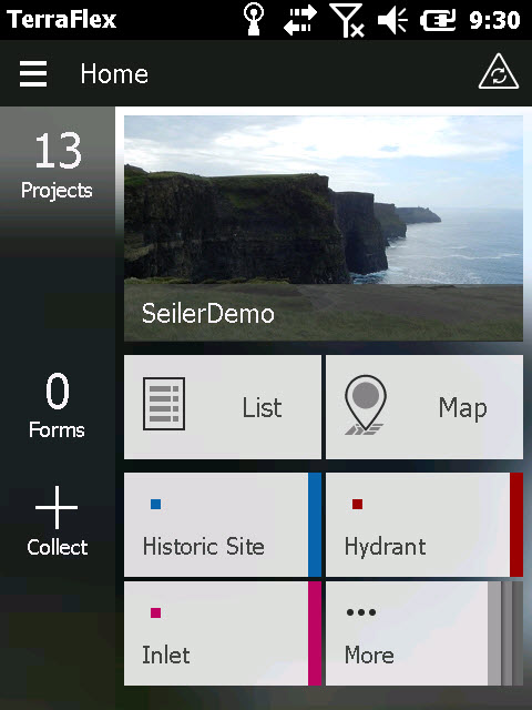
TerraFlex main screen January 2015_Geo7x_1

 TerraFlex Main Website

TerraFlex User Guides

TerraFlex Advanced What’s New January 2015 video

TerraFlex Advanced How To Video

Trimble InSphere/TerraFlex Cloud planned maintenance January 6th 2015

When: On January 6th 2015 from 12:30 p.m. PST (2:30 p.m. Central time) for approximately 3 hours.

See and click on the image below or visit the Trimble InSphere website for more information.

TerraFlex January 6 2015 maint

Are you receiving the Trimble Mapping Customer Newsletter?


Sign up for the Trimble Mapping and GIS Customer Newsletter.


Trimble Registration website

  • After you have created an account you can look at “Manage Communications”.  Then you can click on “Update” to then select which Trimble Newsletters you wish to receive.  Also, if you are the registrant of your Trimble Mapping products you can select “Warranty and Enhancement Expiry Notification”.  This will send out an email reminder of product maintenance expiration.
  • This website can also help you keep track of the Trimble MGIS products that your organization owns.  The Trimble MGIS products are tied to an e-mail address in your organization upon time of purchase.  The registrant can be changed if you notify your Trimble Mapping dealer.

Click here to see the Trimble MGIS Customer Newsletter archives

Also see Trimble MGIS Customer Stories

Trimble Mapping Customer Stories

Geo 7X NEW OS 6.7.15 as of December 2014

Geo 7x and TerraSync December 2014

OS 6.7.15 for the Geo7X here is what is new:

Resolved issues and enhancements:

  • Resolving the issue where sometimes the preview window of the camera is just a black screen preventing the user from taking a picture or using the laser rangefinder.
  • Resolving an issue where sometimes the Sensor Calibration process would not calibrate successfully.
  • Resolves an issue where the handheld crashes when attempting to shut down or reset.

The multi-language provisioned FULL OS 6.7.15  installation file includes 4 more updates than the general update provides.

  • GNSS firmware version 4.10.2
  • Support for RTX
  • Trimble Rangefinder Utility version 1.2
  • Trimble TerraFlex™ field client software
  • SIDE NOTE:  The FULL OS 6.7.15 will wipe the Geo clean.

**Recommendation: plug the power cord into the Geo 7x when upgrading Operating Systems.

1. Click on Geo7 Downloads

2. Click on Trimble Geo 7 Series Operating System

3. Click on Geo 7X Operating System v6.7.15

  • Please click on and download the Release Notes.  Read the Release Notes before install the OS 6.7.15 onto the Geo 7x
  • The Operating System 6.7.15 – UPDATE PACKAGE FROM v6.7.13  – Use this PKS file to update the operating system of your Geo 7X handheld from version 6.7.13 to 6.7.15.  This will not wipe the Geo clean.
  • The Operating System 6.7.15 – FULL OS (99 MB)  – Use this file to fully re-install the Operating System or upgrade a device to Operating System version 6.7.15. This firmware package is fully language provisioned, and also installs GNSS firmware version 4.10.2. The following languages are available for installation on this firmware version: English, Spanish, French, German, Italian, Portuguese, Japanese, Korean, Russian and Traditional Chinese. This OS also bundles the TerraFlex field client, and the Trimble Rangefinder utility.  THIS “FULL OS” WILL WIPE THE GEO 7X CLEAN!!!!  You will then need to reinstall any programs and copy data back to the Geo 7x after this FULL OS is complete.

4. Copy which ever OS you are going to install from your PC to your Geo 7x’s main hard-drive via your USB connection.

5. Find the Geo 7x OS update on your Geo via “File Explore” that is on your Geo 7x and then tap on OS Update with your stylus.  **Recommendation: plug the power cord into the Geo 7x when upgrading Operating Systems.

6. Follow the onscreen prompts and the Geo 7x will reboot and give you a report if the installation was successful.

Mis-shipped Geo soft cases for Geo 7x’s – incorrect size

If you purchased a Geo 7x since its release of November 2013 and the soft case that was shipped with it doesn’t fit properly please let us know.

You can see the difference is sizes (picture below) of the 6000 soft case (10 inches in length) and the Geo 7x soft case (12 inches in length).  The Geo 7x soft case is larger in order to fit the Laser Rangefinder attachment.  With the Laser Rangefinder attached to the Geo 7x the zipper will not close 100% on the smaller soft case.

Geo 6000 soft case on the left and Geo 7x soft case on the right

Geo 6000 soft case on the left and Geo 7x soft case on the right


Geo 6000 soft case has a yellow stripe.  The Geo 7x case is longer.

Geo 6000 soft case has a yellow stripe. The Geo 7x case is longer.

  • Please contact Calvin McRoy cmcroy@seilerinst.com at Seiler Instrument. He will work with you to exchange the smaller soft cases with the proper Geo 7x soft case.  Please note the 7 digit part number and 10 digit part number off the back of your Geo 7x (they are underneath the hand strap) as he will ask you for these.
  • Sorry for the inconvenience in this matter.
  • If you did not purchase your Geo 7x from Seiler Instrument please see the Trimble Dealer locator website as how to contact the proper Trimble dealer in your area.

 Trimble TerraFlex Webinar – December 10, 2014

Learn about  current and future software functions with the Trimble TerraFlex software platform.

When: December 10, 2014

Times: 8am MST or 4pm MST

Registration:  Trimble TerraFlex Webinar – December 10, 2014

terraflexnov2014webinarimage


Trimble® TerraFlex™ software—the flexible, configurable, cross-platform solution for robust data collection—now supports data update workflows to ensure you are working with most up to date data, always.

Whatever your workflow requires, with TerraFlex you can take existing location-based, asset, or GIS data into the field and update a wide range of attributes. Providing a rich set of tools that work for you whether you are collecting street sign inventories, forest or environmental conditions, water system assets, or utility assets, Trimble TerraFlex software makes sure your data is up to the minute.

Ensure your organization has the most up-to-date information on its assets for making the right decisions and putting efficient maintenance plans in place with a new Trimble® TerraFlex™ offering that expands the existing TerraFlex platform through new data update workflows. These new workflows will enable you to import pre-existing or pre-collected asset or GIS data into your TerraFlex projects and make real-time updates to it in the field.

In this webinar learn
• What the Trimble TerraFlex data update workflow looks like from start to finish
• How to simply configure TerraFlex to meet your specific workflow needs
• How TerraFlex streamlines your operations with efficient task and data management

No experience with Trimble TerraFlex software is required. If your organization does field work, learn how data collection and update with TerraFlex is fast, simple, and reliable.


TerraFlex main Website:  TerraFlex Data Collection

TerraFlex What’s New, Resources & FAQ’s: What’s New and Additional Resources

TerraFlex workflow in the new Trimble Positions Desktop Add-in 10.3 Release November 24th, 2014.